Property Record
93 Redneck Ave, Little Ferry, NJ 07643
NEARBY LISTINGS FOR SALE OR LEASE
-
-
-
-
-
-
-
No Photo
-
View all Little Ferry listings for sale on LoopNet.com
Property Detail
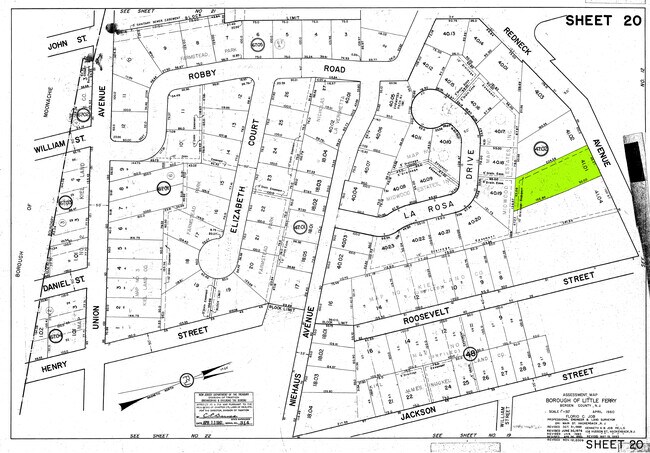
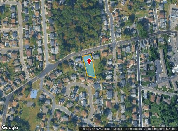
93 Redneck Ave
New York-Jersey City-White Plains, NY-NJ
0.424 AC
30-00047-02-00041-01
Bergen
Vacantlandnec
New Jersey
AE
41.1
34003C0256H
0.42 AC
2024
Meadowlands
2025
Northern New Jersey
029200
DEMOGRAPHICS near 93 Redneck Ave
1 Mile
3 Mile
5 Mile
2024 Total Population
14,221
159,322
650,537
2029 Population
13,874
156,061
636,224
Pop Growth 2024-2029
(2.44%)
(2.05%)
(2.20%)
Average Age
42
41
40
2024 Total Households
5,418
60,662
242,499
HH Growth 2024-2029
(2.44%)
(2.02%)
(2.18%)
Median Household Inc
$83,319
$81,547
$80,505
Avg Household Size
2.50
2.50
2.60
2024 Avg HH Vehicles
2.00
2.00
1.00
Median Home Value
$410,779
$443,439
$456,760
Median Year Built
1962
1959
1958
Nearby Places
Map Layers
Map Styles
 Street
 Aerial
- Restaurants
- Banks
- Shops
- Fitness
- Groceries
PUBLIC TRANSPORTATION
COMMUTER RAIL
Teterboro (Pascack Valley Line - NJ Transit Commuter Rail (NJ Transit))
DRIVE
WALK
Distance
Teterboro (Pascack Valley Line - NJ Transit Commuter Rail (NJ Transit))
4 min
1.9 mi
Wood Ridge (Pascack Valley Line - NJ Transit Commuter Rail (NJ Transit))
DRIVE
WALK
Distance
Wood Ridge (Pascack Valley Line - NJ Transit Commuter Rail (NJ Transit))
5 min
2.4 mi
AIRPORT
Newark Liberty International
DRIVE
WALK
Distance
Newark Liberty International
20 min
13.8 mi
LaGuardia
DRIVE
WALK
Distance
LaGuardia
31 min
16.6 mi
John F Kennedy International
DRIVE
WALK
Distance
John F Kennedy International
43 min
27.6 mi
Freight Ports
Maher Terminal
DRIVE
WALK
Distance
Maher Terminal
27 min
16.5 mi
SALE & LEASE HISTORY
LISTING DATE
SALE/LEASE

Sep 30, 2021
For Sale
Nearby Properties
Address
Land Use
TOTAL SIZE
Lot Size
Zoning
Address
Land Use
TOTAL SIZE
Lot Size
Zoning
Address
Land Use
TOTAL SIZE
Lot Size
Zoning
488,779 SF
7.55 AC
HCS
Address
Land Use
TOTAL SIZE
Lot Size
Zoning
Address
Land Use
TOTAL SIZE
Lot Size
Zoning
4,014 SF
21 AC
Address
Land Use
TOTAL SIZE
Lot Size
Zoning
612 AC
SEA
Address
Land Use
TOTAL SIZE
Lot Size
Zoning
335.71 AC
AF
Address
Land Use
TOTAL SIZE
Lot Size
Zoning
Address
Land Use
TOTAL SIZE
Lot Size
Zoning
Address
Land Use
TOTAL SIZE
Lot Size
Zoning
Address
Land Use
TOTAL SIZE
Lot Size
Zoning
Address
Land Use
TOTAL SIZE
Lot Size
Zoning
Address
Land Use
TOTAL SIZE
Lot Size
Zoning
Address
Land Use
TOTAL SIZE
Lot Size
Zoning
9.57 AC
I2
Address
Land Use
TOTAL SIZE
Lot Size
Zoning
4.37 AC
HCS
Address
Land Use
TOTAL SIZE
Lot Size
Zoning
68.93 AC
Address
Land Use
TOTAL SIZE
Lot Size
Zoning
281,720 SF
3.93 AC
R-3
Address
Land Use
TOTAL SIZE
Lot Size
Zoning
20.07 AC
H
Address
Land Use
TOTAL SIZE
Lot Size
Zoning
Address
Land Use
TOTAL SIZE
Lot Size
Zoning
26 AC
H
Address
Land Use
TOTAL SIZE
Lot Size
Zoning
608,596 SF
27.10 AC
LID
Address
Land Use
TOTAL SIZE
Lot Size
Zoning
232,368 SF
5.10 AC
Address
Land Use
TOTAL SIZE
Lot Size
Zoning
30.46 AC
I
Address
Land Use
TOTAL SIZE
Lot Size
Zoning
29 AC
H
Address
Land Use
TOTAL SIZE
Lot Size
Zoning
2.55 AC
RC-1
Address
Land Use
TOTAL SIZE
Lot Size
Zoning
261,303 SF
5.60 AC
O
Address
Land Use
TOTAL SIZE
Lot Size
Zoning
8.79 AC
Address
Land Use
TOTAL SIZE
Lot Size
Zoning
394,046 SF
1.88 AC
R3
Address
Land Use
TOTAL SIZE
Lot Size
Zoning
2,191 SF
1.34 AC
B2
Address
Land Use
TOTAL SIZE
Lot Size
Zoning
13 AC
B-3
Address
Land Use
TOTAL SIZE
Lot Size
Zoning
31,896 SF
1.64 AC
O
The World's #1 Commercial Real Estate Marketplace
Connect with us
© 2025 CoStar Group
The information above has been obtained from sources believed reliable. While we do not doubt its accuracy we have not verified it and make no guarantee, warranty or representation about it. It is your responsibility to independently confirm its accuracy and completeness. Any projections, opinions, assumptions, or estimates used are for example only and do not represent the current or future performance of the property. The value of this transaction to you depends on tax and other factors which should be evaluated by your tax, financial, and legal advisors. You and your advisors should conduct a careful, independent investigation of the property to determine to your satisfaction the suitability of the property for your needs.